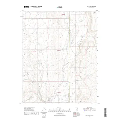
2018 Map of Fort Defiance
USGS Topo · Published 2018About this map
Black Creek Valley sits at the geological intersection of the Chuska Mountains and the Defiance Plateau, spanning the state line between Apache County, Arizona, and McKinley County, New Mexico. The landscape is defined by a complex drainage system, where Black Creek and Bonito Cr are joined by numerous ephemeral channels such as Twin Buttes Wash, Meadow Wash, and White Clay Spring Wash. This 2018 survey reveals a network of tribal and local routes, including Indian Rte 112 and Kit Carson Dr, providing access to isolated water sources like Bonito Spring. The geography shows a transition from the higher elevations of the plateau down into Bonito Canyon, highlighting the importance of seasonal water flow to the local topography and settlement patterns in this part of the Navajo Nation.
Find a feature on this map
42 named features on this map. Tap any name to fly to it.
Don’t see what you’re looking for? This feature index may not catch every label — zoom into the map to look around manually.
Map Details
Editions of this 2018 Fort Defiance Map
This is the sole edition of this map. No revisions or reprints were ever made.
Other maps of this area

1886 · Wingate
USGS Topo · 1:250,000

1886 · Fort Defiance
USGS Topo · 1:250,000

1892 · Fort Defiance
USGS Topo · 1:250,000

1892 · Wingate
USGS Topo · 1:250,000

1954 · Gallup
USGS Topo · 1:250,000

1955 · Zith-Tusayan Butte 4 NW
USGS Topo · 1:24,000

1955 · Zith-Tusayan Butte 4 NE
USGS Topo · 1:24,000

1955 · Zith-Tusayan Butte 1 SE
USGS Topo · 1:24,000
1955 · Zith-Tusayan Butte 1 NE
USGS Topo · 1:24,000
1955 · Zith-Tusayan Butte 1 NW
USGS Topo · 1:24,000