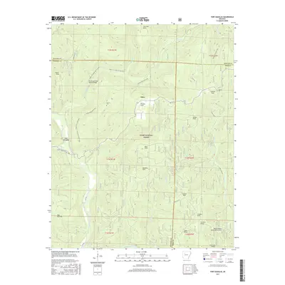
2017 Map of Fort Douglas
USGS Topo · Published 2017About this map
Fort Douglas and the surrounding high ground of the Ozark National Forest define this 2017 survey of the borderlands between Johnson, Pope, and Newton counties. The landscape is characterized by a dense network of drainages including Big Piney Creek, Hurricane Cr, and Sugar Cr, which have carved deep hollows such as Flat Rock Hollow and Cedar Hollow. Notable geological landmarks like the Hurricane Creek Natural Bridge and Buzzard Roost Rocks Natural Arch stand out as significant physical features alongside numerous named peaks like Wheeler Knob and Bald Knob. For family historians, several burial grounds are preserved on these slopes, including Wheeler Cem, Self Cem, and Coleman Cem. The Ozark Highlands Trail winds through the terrain, connecting the small settlement at Dillen with the forest's interior ridges and creeks.
Find a feature on this map
46 named features on this map. Tap any name to fly to it.
Don’t see what you’re looking for? This feature index may not catch every label — zoom into the map to look around manually.
Map Details
Editions of this 2017 Fort Douglas Map
This is the sole edition of this map. No revisions or reprints were ever made.
Other maps of this area

1889 · Treat
USGS Topo · 1:62,500

1889 · Ozone
USGS Topo · 1:62,500

1932 · Treat
USGS Topo · 1:62,500

1933 · Mt Judea
USGS Topo · 1:62,500

1934 · Treat
USGS Topo · 1:62,500

1934 · Ozone
USGS Topo · 1:62,500

1936 · Ozone
USGS Topo · 1:62,500

1940 · Mt Judea
USGS Topo · 1:62,500

1956 · Russellville
USGS Topo · 1:250,000

1964 · Russellville
USGS Topo · 1:250,000