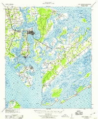
1959 Map of Fort Fremont
USGS Topo · Published 1959About this map
St Helena Island and the surrounding Sea Islands define this coastal landscape, showing the complex network of tidal creeks and marshes before significant modern development. The presence of Ft Fremont at the southern tip of St Helena Island and the Marine Barracks on Parris Island highlights the strategic military importance of the Port Royal Sound area during this era. Navigation and early land transport are evident through the Charleston and Western Carolina railroad, terminating at Beaufort Sta and Port Royal. Numerous artesian wells, labeled as Art Well, are scattered across the islands, reflecting the historical reliance on local groundwater for the settlements at Beaufort, Frogmore, and Wilkins. The map also identifies the historic site of Old Fort and a Quarantine station, offering a window into the region's maritime health and defense history.
Find a feature on this map
68 named features on this map. Tap any name to fly to it.
Don’t see what you’re looking for? This feature index may not catch every label — zoom into the map to look around manually.
Map Details
Editions of this 1959 Fort Fremont Map
This is the sole edition of this map. No revisions or reprints were ever made.
Other maps of this area

1918 · Green Pond
USGS Topo · 1:62,500

1918 · Yemassee
USGS Topo · 1:62,500

1919 · Edisto Island
USGS Topo · 1:62,500

1920 · Okatie
USGS Topo · 1:62,500

1920 · St. Helena Sound
USGS Topo · 1:62,500

1920 · Hilton Head
USGS Topo · 1:62,500

1920 · Bluffton
USGS Topo · 1:62,500

1942 · Okatie
USGS Topo · 1:62,500

1943 · Edisto Island
USGS Topo · 1:62,500

1943 · Yemassee
USGS Topo · 1:62,500