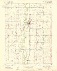
1950 Map of Fort Lupton
USGS Topo · Published 1950About this map
The South Platte River carves a fertile path through Weld County, anchoring the agricultural and rail economy at mid-century. The Union Pacific line runs parallel to the river, serving the concentrated town center of Fort Lupton and the smaller settlement of Wattenberg. This 1950 edition illustrates a landscape defined by water management, with a complex network including the Fulton, Brighton, and Bull ditches divert water across the plains to support local farms.
Find a feature on this map
20 named features on this map. Tap any name to fly to it.
Don’t see what you’re looking for? This feature index may not catch every label — zoom into the map to look around manually.
Map Details
Editions of this 1950 Fort Lupton Map
2 editions found
Other maps of this area

1890 · East Denver
USGS Topo · 1:125,000

1902 · Greeley
USGS Topo · 1:125,000

1940 · Brighton
USGS Topo · 1:31,680

1940 · Eastlake
USGS Topo · 1:31,680

1942 · Mile High Lakes
USGS Topo · 1:31,680

1944 · Brighton
USGS Topo · 1:31,680

1944 · Eastlake
USGS Topo · 1:31,680

1949 · Gowanda
USGS Topo · 1:24,000

1949 · Fort Lupton
USGS Topo · 1:24,000

1949 · Platteville
USGS Topo · 1:24,000