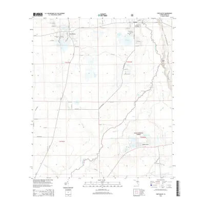
2015 Map of Fort McCoy
USGS Topo · Published 2015About this map
Fort McCoy and Eureka anchor this northern Marion County landscape, situated near the winding course of the Ocklawaha River. The area is characterized by a dense network of water bodies, including Silver Lake, Graveyard Lake, and the larger Lake Lynne. Much of the eastern and southern portion of the quadrangle is preserved within the Ocala National Forest, where the Florida National Scenic Trail traverses the pine and oak scrub environment near Parramore Prairie. Genealogy researchers will find several well-documented burial sites such as the Fort McCoy Cem, Pleasant Grove Cem, and Eureka Cem, which reflect the long-standing community roots in the region. The map also captures the hydraulic complexity of the area, featuring named watercourses like Eaton Creek, Cedar Creek, and the Dead River, alongside distinctive terrain markers such as Sunday Bluff overlooking the river valley.
Find a feature on this map
75 named features on this map. Tap any name to fly to it.
Don’t see what you’re looking for? This feature index may not catch every label — zoom into the map to look around manually.
Map Details
Editions of this 2015 Fort McCoy Map
This is the sole edition of this map. No revisions or reprints were ever made.
Other maps of this area

1893 · Citra
USGS Topo · 1:62,500

1895 · Citra
USGS Topo · 1:62,500

1895 · Ocala
USGS Topo · 1:62,500

1954 · Gainesville
USGS Topo · 1:250,000

1954 · Daytona Beach
USGS Topo · 1:250,000

1958 · Daytona Beach
USGS Topo · 1:250,000

1958 · Gainesville
USGS Topo · 1:250,000

1959 · Gainesville
USGS Topo · 1:250,000

1964 · Daytona Beach
USGS Topo · 1:250,000
1967 · Citra
USGS Topo · 1:24,000