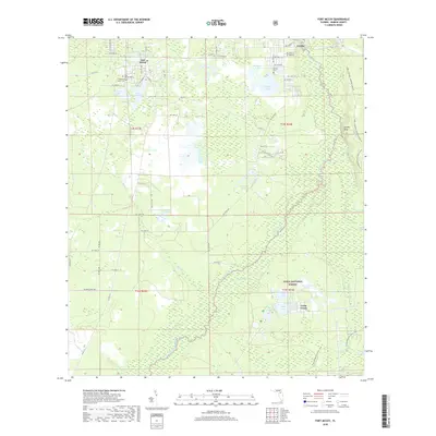
2018 Map of Fort McCoy
USGS Topo · Published 2018About this map
Fort McCoy and the neighboring community of Eureka serve as the primary hubs in this corner of Marion County, where the dense wetlands of the Ocala National Forest meet the winding course of the Ocklawaha River. The landscape is a complex network of hydrologic features, from the flowing Dead River and Daisy Cr to the quiet waters of Graveyard Lake, Silver Lake, and Lake Lynne. Genealogists will find several notable burial grounds, including Fort McCoy Cem, Pleasant Grove Cem, and Eureka Cem, which anchor the local history of these rural Florida settlements.
Find a feature on this map
68 named features on this map. Tap any name to fly to it.
Don’t see what you’re looking for? This feature index may not catch every label — zoom into the map to look around manually.
Map Details
Editions of this 2018 Fort McCoy Map
This is the sole edition of this map. No revisions or reprints were ever made.
Other maps of this area

1893 · Citra
USGS Topo · 1:62,500

1895 · Citra
USGS Topo · 1:62,500

1895 · Ocala
USGS Topo · 1:62,500

1954 · Gainesville
USGS Topo · 1:250,000

1954 · Daytona Beach
USGS Topo · 1:250,000

1958 · Daytona Beach
USGS Topo · 1:250,000

1958 · Gainesville
USGS Topo · 1:250,000

1959 · Gainesville
USGS Topo · 1:250,000

1964 · Daytona Beach
USGS Topo · 1:250,000
1967 · Citra
USGS Topo · 1:24,000