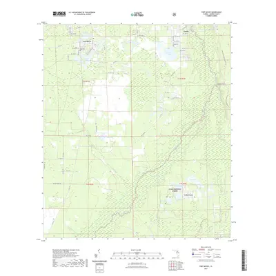
2021 Map of Fort McCoy
USGS Topo · Published 2021About this map
The Ocklawaha River and its meandering tributaries, including the Dead River and Daisy Cr, define this part of the Florida interior. Settlement is concentrated around Fort McCoy in the northwest and Eureka in the northeast, with much of the eastern landscape preserved within the Ocala National Forest. This modern survey reveals a complex hydrological network where the river system interacts with named wetlands and prairies like Oakie Head and Parramore Prairie. Genealogists will find significant value in the detailed location of local burial grounds, including the Fort McCoy Cem, the Fort McCoy Negro Cem, and Eureka Cem. The transition from the established community of Cedar Creek to the expansive timberlands and lakes like Graveyard Lake and Lake Lynne shows a landscape deeply tied to its water resources and forest conservation history.
Find a feature on this map
67 named features on this map. Tap any name to fly to it.
Don’t see what you’re looking for? This feature index may not catch every label — zoom into the map to look around manually.
Map Details
Editions of this 2021 Fort McCoy Map
This is the sole edition of this map. No revisions or reprints were ever made.
Other maps of this area

1893 · Citra
USGS Topo · 1:62,500

1895 · Citra
USGS Topo · 1:62,500

1895 · Ocala
USGS Topo · 1:62,500

1954 · Gainesville
USGS Topo · 1:250,000

1954 · Daytona Beach
USGS Topo · 1:250,000

1958 · Daytona Beach
USGS Topo · 1:250,000

1958 · Gainesville
USGS Topo · 1:250,000

1959 · Gainesville
USGS Topo · 1:250,000

1964 · Daytona Beach
USGS Topo · 1:250,000
1967 · Citra
USGS Topo · 1:24,000