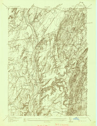
1935 Map of Fort Miller
USGS Topo · Published 1935About this map
The Hudson River serves as the primary corridor of this 1930s landscape, marking the boundary between Washington and Saratoga counties. The engineering of the Barge Canal is a focal point, featuring Lock No 6 near Fort Miller, while the river itself is dotted with numerous islands like Thompson Island and Griffin Island. The map records a rural educational network that was still very much decentralized, with one-room schoolhouses such as Argyle Sch, Lick Springs Sch, and Bald Mountain Sch serving small agricultural pockets.
Find a feature on this map
48 named features on this map. Tap any name to fly to it.
Don’t see what you’re looking for? This feature index may not catch every label — zoom into the map to look around manually.
Map Details
Editions of this 1935 Fort Miller Map
This is the sole edition of this map. No revisions or reprints were ever made.
Other maps of this area

1893 · Fort Ann
USGS Topo · 1:62,500

1895 · Cambridge
USGS Topo · 1:62,500

1895 · Fort Ann
USGS Topo · 1:62,500

1895 · Glens Falls
USGS Topo · 1:62,500

1897 · Glens Falls
USGS Topo · 1:62,500

1898 · Cambridge
USGS Topo · 1:62,500

1898 · Fort Ann
USGS Topo · 1:62,500

1900 · Schuylerville
USGS Topo · 1:62,500

1901 · Fort Ann
USGS Topo · 1:62,500

1901 · Cambridge
USGS Topo · 1:62,500