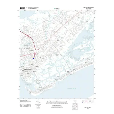
2011 Map of Fort Moultrie
USGS Topo · Published 2011About this map
Fort Moultrie anchors the southern tip of this coastal survey, overlooking the Atlantic Ocean and the entrance to the harbor. The landscape is defined by the shifting barrier islands of Sullivans Island and the Isle of Palms, separated by the waters surrounding Goldbug Island. On the mainland, the sprawling residential growth of Mount Pleasant is evident in neighborhoods like Cassina Heights and Osceola Heights, which have expanded across the lowcountry terrain.
Find a feature on this map
72 named features on this map. Tap any name to fly to it.
Don’t see what you’re looking for? This feature index may not catch every label — zoom into the map to look around manually.
Map Details
Editions of this 2011 Fort Moultrie Map
This is the sole edition of this map. No revisions or reprints were ever made.
Other maps of this area

1919 · The Jetties
USGS Topo · 1:21,120

1919 · Capers Island
USGS Topo · 1:21,120

1919 · Wando
USGS Topo · 1:21,120

1919 · Melgrove
USGS Topo · 1:21,120

1919 · Charleston
USGS Topo · 1:21,120

1919 · James Island
USGS Topo · 1:21,120

1919 · Fort Moultrie
USGS Topo · 1:21,120

1919 · Sewee Bay
USGS Topo · 1:21,120

1940 · Melgrove
USGS Topo · 1:24,000

1943 · Capers Island
USGS Topo · 1:24,000