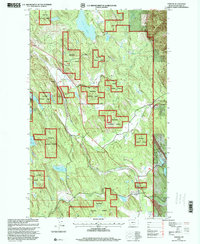
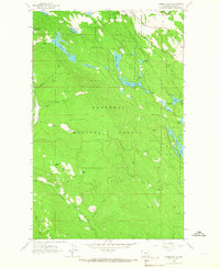
1997 Map of Fortine
USGS Topo · Published 2000About this map
Fortine stands as the primary settlement in this corner of northwest Montana, situated along the Burlington Northern rail line and Fortine Creek. The landscape is a complex patchwork of private holdings and the Kootenai National Forest, defined by a dense network of water bodies including Glen Lake, Murphy Lake, and the smaller Barnaby Lake. The presence of the Crystal Lake Resort near Crystal Lake and a local Golf Course suggests the area's development as a recreational destination by the late 1990s, even as traditional landmarks like the local Cemetery and various gravel pits remain. The Tobacco River and Therriault Creek drain this section of the Whitefish Range, where the intersection of timber management and mountain tourism is clearly visible through the numerous forest roads and trails that traverse the terrain.
Find a feature on this map
45 named features on this map. Tap any name to fly to it.
Don’t see what you’re looking for? This feature index may not catch every label — zoom into the map to look around manually.
Map Details
Editions of this 1997 Fortine Map
This is the sole edition of this map. No revisions or reprints were ever made.
Other maps of this area

1913 · Stryker
USGS Topo · 1:125,000

1916 · Stryker
USGS Topo · 1:125,000

1957 · Kalispell
USGS Topo · 1:250,000

1960 · Kalispell
USGS Topo · 1:250,000

1961 · Kalispell
USGS Topo · 1:250,000
1963 · Eureka North
USGS Topo · 1:24,000
1963 · Mount Marston
USGS Topo · 1:24,000
1963 · Ksanka Peak
USGS Topo · 1:24,000
1963 · Eureka South
USGS Topo · 1:24,000
1963 · Stryker
USGS Topo · 1:24,000