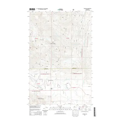
2014 Map of Fortson
USGS Topo · Published 2014About this map
Fortson and Swede Heaven occupy the valley floor where the river bends south, situated at the edge of the Mount Baker National Forest. This 2014 survey records a landscape defined by the drainage of the N Fork Stillaguamish River and its various tributaries, including Squire Cr and Ashton Cr. The northern half of the map is dominated by high-elevation terrain features like Segelsen Ridge and Coney Pass, while the southern portion shows more concentrated human activity. A legacy of local industry is visible in the presence of the Fortson Mill Pond and Fortson Ponds, accessed by Fortson Mill Rd. The transition between the Skagit and Snohomish County line occurs near the high peaks of Round Mtn, separating the river valley from the higher alpine reaches of the national forest.
Find a feature on this map
50 named features on this map. Tap any name to fly to it.
Don’t see what you’re looking for? This feature index may not catch every label — zoom into the map to look around manually.
Map Details
Editions of this 2014 Fortson Map
This is the sole edition of this map. No revisions or reprints were ever made.
Other maps of this area

1899 · Stillaguamish
USGS Topo · 1:125,000

1901 · Stilaguamish
USGS Topo · 1:125,000

1955 · Concrete
USGS Topo · 1:250,000

1956 · Oso
USGS Topo · 1:62,500

1956 · Granite Falls
USGS Topo · 1:62,500

1957 · Silverton
USGS Topo · 1:62,500

1958 · Concrete
USGS Topo · 1:250,000

1962 · Concrete
USGS Topo · 1:250,000
1966 · Darrington
USGS Topo · 1:24,000
1966 · Fortson
USGS Topo · 1:24,000