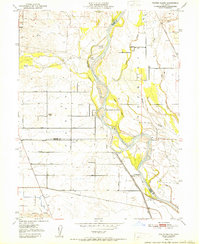
1951 Map of Foster Island
USGS Topo · Published 1951About this map
The Sacramento River meanders through this agricultural corridor, defining a landscape of complex waterways and seasonal islands. This early 1950s survey documents a highly structured rural grid west of the river, where numerous family-named roads like Moller Ave and Lindsay Ave connect the small community of Capay and its local Capay Sch. The influence of the river on local commerce and history is evident in the identification of historical landing points, such as Wilson Landing and Mcintosh Ldg, which suggest a time when river transport was more integral to the region's economy.
Find a feature on this map
34 named features on this map. Tap any name to fly to it.
Don’t see what you’re looking for? This feature index may not catch every label — zoom into the map to look around manually.
Map Details
Editions of this 1951 Foster Island Map
This is the sole edition of this map. No revisions or reprints were ever made.
Other maps of this area

1891 · Chico
USGS Topo · 1:125,000

1893 · Chico
USGS Topo · 1:125,000

1895 · Chico
USGS Topo · 1:125,000

1904 · Vina
USGS Topo · 1:62,500

1906 · Willows
USGS Topo · 1:62,500

1912 · Nord
USGS Topo · 1:31,680

1912 · Chico Landing
USGS Topo · 1:31,680

1912 · Singer Creek
USGS Topo · 1:31,680

1914 · Kirkwood
USGS Topo · 1:31,680

1914 · Orland
USGS Topo · 1:31,680