
1950 Map of Fountain NE
USGS Topo · Published 1950About this map
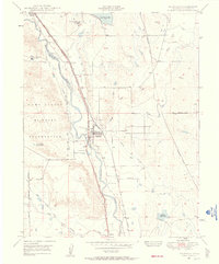
Williams Creek and Chico Creek define the drainage patterns across this high plains landscape in El Paso County. Mapped from aerial photography taken just after World War II, the sheet highlights a ranching economy dependent on dispersed water sources, evidenced by several Windmill sites and the Bailey Windmill. Named outposts like Slate Ranch and Kane Ranch serve as primary landmarks in an area otherwise characterized by its undulating terrain and the straight transit of Squirrel Creek Road. An Underground Pipeline cuts through the southwestern corner, reflecting the early infrastructure of the region during the late 1940s. This survey provides a precise record of rural property development and water resource management in the Colorado interior before modern suburban expansion reached these reaches.
Find a feature on this map
9 named features on this map. Tap any name to fly to it.
Don’t see what you’re looking for? This feature index may not catch every label — zoom into the map to look around manually.
Map Details
Editions of this 1950 Fountain NE Map
This is the sole edition of this map. No revisions or reprints were ever made.
Other maps of this area

1893 · Big Springs
USGS Topo · 1:125,000

1893 · Colorado Springs
USGS Topo · 1:125,000

1909 · Colorado Springs
USGS Topo · 1:125,000

1942 · Colorado Springs
USGS Topo · 1:125,000

1948 · Fountain SE
USGS Topo · 1:24,000
1948 · Fountain
USGS Topo · 1:24,000

1948 · Falcon
USGS Topo · 1:62,500

1949 · Buttes
USGS Topo · 1:24,000

1949 · Corral Bluffs
USGS Topo · 1:24,000
1950 · Elsmere
USGS Topo · 1:24,000