
1948 Map of Fountain
USGS Topo · Published 1958About this map
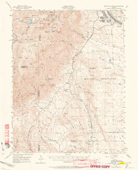
Fountain serves as the central hub of this post-war landscape, situated where the Atchison Topeka and Santa Fe Western and Denver and Rio Grande Western railroads run parallel along the eastern bank of Fountain Creek. The map documents a period of significant military and agricultural coordination in El Paso County. Large-scale water management is evident through the presence of the Chandler Canal No 30 and Chilcott Canal, which divert water to support the surrounding ranchlands. To the west, the Camp Carson Military Reservation boundary indicates the substantial federal footprint in the region. Educational and community foundations are well-represented by the Fountain Valley School and Fairview Cemetery, providing researchers with specific touchpoints for local mid-century genealogy. The intricate network of smaller waterways like Little Fountain Creek and Rock Creek underscores the complex drainage patterns of the high plains terrain.
Find a feature on this map
27 named features on this map. Tap any name to fly to it.
Don’t see what you’re looking for? This feature index may not catch every label — zoom into the map to look around manually.
Map Details
Editions of this 1948 Fountain Map
This is the sole edition of this map. No revisions or reprints were ever made.
Other maps of this area

1893 · Colorado Springs
USGS Topo · 1:125,000

1909 · Colorado Springs
USGS Topo · 1:125,000

1942 · Colorado Springs
USGS Topo · 1:125,000

1948 · Timber Mountain
USGS Topo · 1:24,000

1948 · Fountain SE
USGS Topo · 1:24,000

1948 · Colorado Springs
USGS Topo · 1:62,500

1948 · Colorado Springs
USGS Topo · 1:24,000

1948 · Cheyenne Mountain
USGS Topo · 1:24,000

1948 · Falcon
USGS Topo · 1:62,500
1948 · Mount Big Chief
USGS Topo · 1:62,500