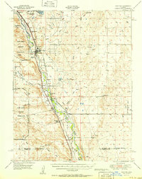
1951 Map of Fountain
USGS Topo · Published 1951About this map
Fountain serves as the central hub of this mid-century landscape, where the agricultural life of the High Plains meets the expanding infrastructure of the southern Front Range. The corridor is defined by the parallel paths of the Atchison Topeka and Santa Fe RR and the Denver and Rio Grande Western RR, which trace the course of Fountain Creek through El Paso County. This transit spine supported a network of family-held lands such as the McCandlish Ranch, Hammer Ranch, and 7 L Bar Ranch.
Find a feature on this map
51 named features on this map. Tap any name to fly to it.
Don’t see what you’re looking for? This feature index may not catch every label — zoom into the map to look around manually.
Map Details
Editions of this 1951 Fountain Map
2 editions found
Other maps of this area

1891 · Pueblo
USGS Topo · 1:125,000

1891 · Nepesta
USGS Topo · 1:125,000

1893 · Nepesta
USGS Topo · 1:125,000

1893 · Big Springs
USGS Topo · 1:125,000

1893 · Colorado Springs
USGS Topo · 1:125,000

1894 · Pueblo
USGS Topo · 1:125,000

1896 · Pueblo
USGS Topo · 1:125,000

1897 · Pueblo
USGS Topo · 1:125,000

1904 · Nepesta
USGS Topo · 1:125,000

1909 · Colorado Springs
USGS Topo · 1:125,000