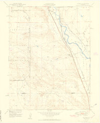
1949 Map of Buttes
USGS Topo · Published 1949About this map
The eastern edge of the Camp Carson Military Reservation dominates the high ground here, transitioning sharply into the agricultural and transit corridor of Fountain Creek. This 1949 survey illustrates a landscape defined by water management and heavy rail infrastructure, where numerous irrigation channels like Hanover Ditch and the Tom Wanless Ditch parallel the creek bed to support local ranching.
Find a feature on this map
30 named features on this map. Tap any name to fly to it.
Don’t see what you’re looking for? This feature index may not catch every label — zoom into the map to look around manually.
Map Details
Editions of this 1949 Buttes Map
2 editions found
Other maps of this area

1891 · Pueblo
USGS Topo · 1:125,000

1893 · Colorado Springs
USGS Topo · 1:125,000

1894 · Pueblo
USGS Topo · 1:125,000

1896 · Pueblo
USGS Topo · 1:125,000

1897 · Pueblo
USGS Topo · 1:125,000

1909 · Colorado Springs
USGS Topo · 1:125,000

1942 · Colorado Springs
USGS Topo · 1:125,000

1948 · Timber Mountain
USGS Topo · 1:24,000

1948 · Fountain SE
USGS Topo · 1:24,000

1948 · Fountain
USGS Topo · 1:24,000