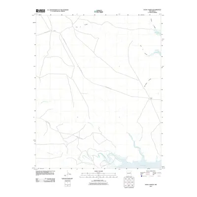
2010 Map of Four V Ranch
USGS Topo · Published 2010About this map
The ranching heritage of San Miguel County is etched into the landscape of this New Mexico quadrangle, centered on the titular Four V Ranch and the small settlement of Garcia. The terrain is defined by a network of drainage systems that feed into the large expanse of Conchas Lake at the southern and eastern margins. The Conchas River and its tributaries, including Trementina Creek, have carved distinct relief into the high desert, creating natural corridors such as Four V Canyon and Jose Maria Canyon. This road network, including County Road C-57-A and County Road C-57-B, illustrates the sparse but essential infrastructure connecting remote ranching outposts to the broader region during the early twenty-first century.
Find a feature on this map
11 named features on this map. Tap any name to fly to it.
Don’t see what you’re looking for? This feature index may not catch every label — zoom into the map to look around manually.
Map Details
Editions of this 2010 Four V Ranch Map
This is the sole edition of this map. No revisions or reprints were ever made.
Other maps of this area

1954 · Santa Fe
USGS Topo · 1:250,000

1958 · Santa Fe
USGS Topo · 1:250,000

1967 · Tenaja Mesa
USGS Topo · 1:24,000

1968 · Conchas Dam
USGS Topo · 1:24,000

1972 · Variadero
USGS Topo · 1:24,000

1972 · Four V Ranch
USGS Topo · 1:24,000

1972 · La Silla
USGS Topo · 1:24,000
1972 · Bookout Ranch
USGS Topo · 1:24,000
1972 · San Ramon
USGS Topo · 1:24,000

1972 · Wade Canyon
USGS Topo · 1:24,000