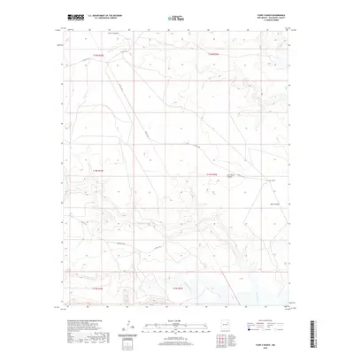
2020 Map of Four V Ranch
USGS Topo · Published 2020About this map
Four V Ranch anchors this high-desert ranching landscape in San Miguel County, where drainage systems and county roads dictate the movement of people and livestock. The area is defined by the winding course of the Conchas River in the south and the Trementina Cr, which cuts across the central terrain. Topographically, the land is carved by significant depressions including Four V Canyon and Jose Maria Canyon, providing natural landmarks for local navigation. A network of rural routes, including Trementina Rd and Co Rd C-57-B, connects the remote ranching outpost to the broader region. This 2020 record reflects the persistent land-use patterns of northeastern New Mexico, highlighting how established property names like Boot Canyon remain key identifiers in the vast high-plains geography.
Find a feature on this map
17 named features on this map. Tap any name to fly to it.
Don’t see what you’re looking for? This feature index may not catch every label — zoom into the map to look around manually.
Map Details
Editions of this 2020 Four V Ranch Map
This is the sole edition of this map. No revisions or reprints were ever made.
Other maps of this area

1954 · Santa Fe
USGS Topo · 1:250,000

1958 · Santa Fe
USGS Topo · 1:250,000

1967 · Tenaja Mesa
USGS Topo · 1:24,000

1968 · Conchas Dam
USGS Topo · 1:24,000

1972 · Variadero
USGS Topo · 1:24,000

1972 · Four V Ranch
USGS Topo · 1:24,000

1972 · La Silla
USGS Topo · 1:24,000
1972 · Bookout Ranch
USGS Topo · 1:24,000
1972 · San Ramon
USGS Topo · 1:24,000

1972 · Wade Canyon
USGS Topo · 1:24,000