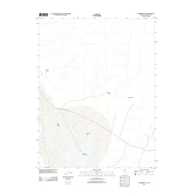
2011 Map of Fourmile Flat
USGS Topo · Published 2011About this map
Salt Wells Marsh and the expansive alkaline expanse of Fourmile Flat dominate this 2011 survey of the Churchill County desert. The landscape is defined by the shifting geography of the Sand Mountain dunes and the surrounding Salt Wells Basin. Human infrastructure in this arid environment is largely dictated by water and recreation, centered on the Sand Mountain Rec Area and sparse livestock improvements such as the Tunnel Spring Windmill and Sand Mountain Windmill. Highway 50 cuts a direct path across the northern reaches of the flat, following a corridor once vital to early transcontinental travel. Rare water sources like Tunnel Spring and Sand Springs provide the only breaks in the dry terrain, while Salt Creek drains toward the basin floor, illustrating the complex internal drainage of the Nevada Great Basin.
Find a feature on this map
11 named features on this map. Tap any name to fly to it.
Don’t see what you’re looking for? This feature index may not catch every label — zoom into the map to look around manually.
Map Details
Editions of this 2011 Fourmile Flat Map
This is the sole edition of this map. No revisions or reprints were ever made.
Other maps of this area

1908 · Carson Sink
USGS Topo · 1:250,000

1910 · Carson Sink
USGS Topo · 1:250,000

1951 · Carson Lake
USGS Topo · 1:62,500

1951 · Allen Springs
USGS Topo · 1:62,500

1957 · Reno
USGS Topo · 1:250,000

1959 · Reno
USGS Topo · 1:250,000

1960 · Reno
USGS Topo · 1:250,000

1972 · Fourmile Flat
USGS Topo · 1:24,000

1972 · Diamond Canyon
USGS Topo · 1:24,000
1972 · Frenchman
USGS Topo · 1:24,000