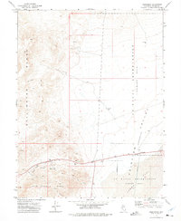
1972 Map of Frenchman
USGS Topo · Published 1975About this map
Stillwater Range peaks and desert lowlands dominate this Nevada landscape during the early 1970s. The small settlement of Frenchman sits along the road at the edge of the Fairview Valley (Depression), a vast expanse designated as part of the U S Naval Reservation (Training Area). Evidence of resource extraction is visible to the west in the Sand Springs Range, where the Summit King Mine and various Prospects are located. The map reveals the stark contrast between the natural geography of Red Top Canyon and Sand Dunes and the military-restricted zones, including a specific U S Naval Reservation (Target Area) in the Flat. Industrial remnants like Tailings and Borrow Pits mark the terrain, offering a clear record of land use in this part of Churchill County.
Find a feature on this map
18 named features on this map. Tap any name to fly to it.
Don’t see what you’re looking for? This feature index may not catch every label — zoom into the map to look around manually.
Map Details
Editions of this 1972 Frenchman Map
2 editions found
Other maps of this area

1908 · Carson Sink
USGS Topo · 1:250,000

1910 · Carson Sink
USGS Topo · 1:250,000

1957 · Reno
USGS Topo · 1:250,000

1959 · Reno
USGS Topo · 1:250,000

1960 · Reno
USGS Topo · 1:250,000

1972 · Pirouette Mtn
USGS Topo · 1:24,000

1972 · Fourmile Flat
USGS Topo · 1:24,000

1972 · Diamond Canyon
USGS Topo · 1:24,000
1972 · Bell Canyon
USGS Topo · 1:24,000
1972 · Drumm Summit
USGS Topo · 1:24,000