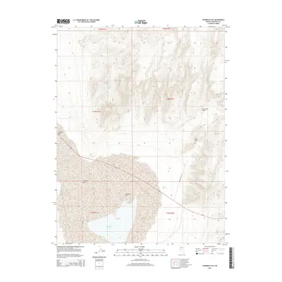
2014 Map of Fourmile Flat
USGS Topo · Published 2014About this map
Salt Wells Marsh and the expansive desert playas of Fourmile Flat dominate this portion of the Great Basin in Churchill County. This arid landscape is defined by its dramatic elevation changes, where the dry basins of Eightmile Flat and Salt Wells Basin sit in the shadow of the Stillwater Range. The presence of Sand Mtn and the nearby Sand Springs indicates a geography shaped by wind and sparse water sources, such as Tunnel Spring tucked into the higher elevations. The map documents the persistent topographical features of this desert environment, including the specialized infrastructure of Sand Mountain Rd providing access to the singular dunes. This 2014 survey serves as a modern baseline for understanding the hydrology and landforms of the Nevada desert prior to further environmental shifts.
Find a feature on this map
15 named features on this map. Tap any name to fly to it.
Don’t see what you’re looking for? This feature index may not catch every label — zoom into the map to look around manually.
Map Details
Editions of this 2014 Fourmile Flat Map
This is the sole edition of this map. No revisions or reprints were ever made.
Other maps of this area

1908 · Carson Sink
USGS Topo · 1:250,000

1910 · Carson Sink
USGS Topo · 1:250,000

1951 · Carson Lake
USGS Topo · 1:62,500

1951 · Allen Springs
USGS Topo · 1:62,500

1957 · Reno
USGS Topo · 1:250,000

1959 · Reno
USGS Topo · 1:250,000

1960 · Reno
USGS Topo · 1:250,000

1972 · Fourmile Flat
USGS Topo · 1:24,000

1972 · Diamond Canyon
USGS Topo · 1:24,000
1972 · Frenchman
USGS Topo · 1:24,000