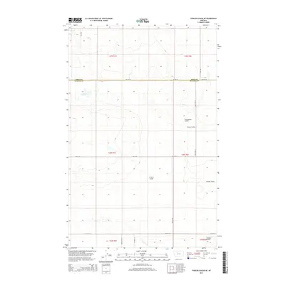
2014 Map of Fowler Coulee NE
USGS Topo · Published 2014About this map
Fowler Reservoir sits at the northern edge of this Pondera County landscape, where the high plains of north-central Montana are carved by a complex network of drainage ravines. The land is defined by these seasonal waterways, including the prominent Fowler Coulee and its neighboring East Powder Coulee, which create a varied topography across the prairie. Evidence of long-standing ranching and agricultural partitions is visible in the rigid grid of rural routes such as Sollid Rd, Larry Bird Rd, and Preputin Rd. This 2014 survey documents the area's sparse but deliberate infrastructure, where individual family names like Valstad Rd and Matheson Rd designate the paths connecting isolated homesteads. The terrain transitions toward the south into Floberg Coulee and Pondera Coulee, illustrating the natural erosion patterns typical of this portion of the Montana-Toole county line.
Find a feature on this map
23 named features on this map. Tap any name to fly to it.
Don’t see what you’re looking for? This feature index may not catch every label — zoom into the map to look around manually.
Map Details
Editions of this 2014 Fowler Coulee NE Map
This is the sole edition of this map. No revisions or reprints were ever made.
Other maps of this area

1920 · Conrad
USGS Topo · 1:125,000

1954 · Shelby
USGS Topo · 1:250,000

1958 · Shelby
USGS Topo · 1:250,000

1967 · Central School
USGS Topo · 1:24,000

1967 · Conrad Butte
USGS Topo · 1:24,000

1967 · Fowler Coulee SW
USGS Topo · 1:24,000

1967 · Fowler Coulee NW
USGS Topo · 1:24,000
1967 · Fowler Coulee SE
USGS Topo · 1:24,000
1967 · Fowler Coulee NE
USGS Topo · 1:24,000

1970 · Sollid School
USGS Topo · 1:24,000