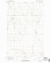
1967 Map of Fowler Coulee NE
USGS Topo · Published 1971About this map
Pondera Coulee and its neighboring drainages carve through this section of the Montana high plains during the mid-1960s. The landscape is defined by the transition between Toole and Pondera Counties, where water management and rural infrastructure supported a sparse but established agricultural community. Key local landmarks like the Hall Community Hall and Christenson Sch provide focal points for researchers tracing family history in this region. The northern portion of the map highlights Fowler Reservoir, a critical water resource for the area. The road network, including the straight reaches of Sollid Road and Midway Road, follows the township and range lines typical of the northern plains settlement patterns, while the branching systems of Powder Coulee and Fowler Coulee dictate the natural contours of the land.
Find a feature on this map
11 named features on this map. Tap any name to fly to it.
Don’t see what you’re looking for? This feature index may not catch every label — zoom into the map to look around manually.
Map Details
Editions of this 1967 Fowler Coulee NE Map
2 editions found
Other maps of this area

1920 · Conrad
USGS Topo · 1:125,000

1954 · Shelby
USGS Topo · 1:250,000

1958 · Shelby
USGS Topo · 1:250,000

1967 · Central School
USGS Topo · 1:24,000

1967 · Conrad Butte
USGS Topo · 1:24,000

1967 · Fowler Coulee SW
USGS Topo · 1:24,000

1967 · Fowler Coulee NW
USGS Topo · 1:24,000
1967 · Fowler Coulee SE
USGS Topo · 1:24,000

1970 · Sollid School
USGS Topo · 1:24,000
1970 · Faris School
USGS Topo · 1:24,000