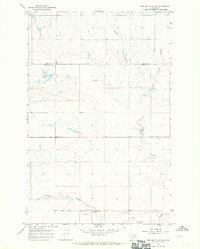
1967 Map of Fowler Coulee NE
USGS Topo · Published 1971About this map
The boundary between Toole County and Pondera County runs through this section of the Montana plains, where the landscape is defined by a network of drainage channels. Fowler Coulee and Powder Coulee weave through the terrain, with the Fowler Reservoir serving as a significant water catchment in the northwest. This area was primarily rural and agricultural in the mid-1960s, evidenced by the straight sections of Sollid Road and Midway Road that cut across the prairie. Local infrastructure is sparse but notable for researchers, including the Christenson Sch and the Hall Community Well. These points, along with scattered Gravel Pits, reflect the essential utilities and educational outposts of a distributed ranching community during the late 1960s.
Find a feature on this map
11 named features on this map. Tap any name to fly to it.
Don’t see what you’re looking for? This feature index may not catch every label — zoom into the map to look around manually.
Map Details
Editions of this 1967 Fowler Coulee NE Map
2 editions found
Other maps of this area

1920 · Conrad
USGS Topo · 1:125,000

1954 · Shelby
USGS Topo · 1:250,000

1958 · Shelby
USGS Topo · 1:250,000

1967 · Central School
USGS Topo · 1:24,000

1967 · Conrad Butte
USGS Topo · 1:24,000

1967 · Fowler Coulee SW
USGS Topo · 1:24,000

1967 · Fowler Coulee NW
USGS Topo · 1:24,000
1967 · Fowler Coulee SE
USGS Topo · 1:24,000
1967 · Fowler Coulee NE
USGS Topo · 1:24,000

1970 · Sollid School
USGS Topo · 1:24,000