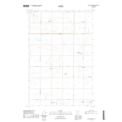
2020 Map of Fowler Coulee NE
USGS Topo · Published 2020About this map
St Olaf Church stands as a spiritual anchor near the northern boundary of this high plains landscape straddling the border of Toole and Pondera counties. The terrain is defined by a network of drainage channels, including Fowler Coulee, East Powder Coulee, and Floberg Coulee, which carve through the agricultural sections. Human presence is marked by a grid of rural roads named for early families and local institutions, such as Christenson School Rd N and S Central School Rd, hinting at the former locations of country schoolhouses that once served this ranching community. The Fowler Reservoir provides a critical water source in the northwest, while the southern reaches descend toward the winding path of Pondera Coulee. This map illustrates the intersection of modern land management and the enduring township-and-range divisions that have organized these northern Montana fields for generations.
Find a feature on this map
28 named features on this map. Tap any name to fly to it.
Don’t see what you’re looking for? This feature index may not catch every label — zoom into the map to look around manually.
Map Details
Editions of this 2020 Fowler Coulee NE Map
This is the sole edition of this map. No revisions or reprints were ever made.
Other maps of this area

1920 · Conrad
USGS Topo · 1:125,000

1954 · Shelby
USGS Topo · 1:250,000

1958 · Shelby
USGS Topo · 1:250,000

1967 · Central School
USGS Topo · 1:24,000

1967 · Conrad Butte
USGS Topo · 1:24,000

1967 · Fowler Coulee SW
USGS Topo · 1:24,000

1967 · Fowler Coulee NW
USGS Topo · 1:24,000
1967 · Fowler Coulee SE
USGS Topo · 1:24,000
1967 · Fowler Coulee NE
USGS Topo · 1:24,000

1970 · Sollid School
USGS Topo · 1:24,000