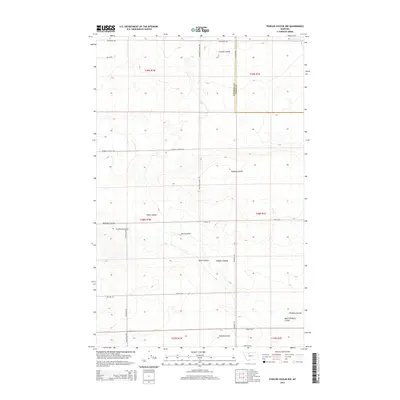
2014 Map of Fowler Coulee NW
USGS Topo · Published 2014About this map
Fowler Coulee and Gibbons Coulee carve through this high Montana prairie landscape along the Pondera Co Toole Co border. The map illustrates a meticulously gridded agricultural region defined by expansive townships and the drainage patterns of numerous small coulees, including Bird Coulee and Favot Coulee. Infrastructure is primarily limited to a network of rural roads that follow section lines, such as Moulton School Rd and Sollid Rd, which provide access to scattered farmsteads and ranches. In the northeast corner, the M Ratzburg Reservoir represents a vital water management feature for the semi-arid environment. The presence of named drainages like Wilcox Coulee and Freebury Coulee suggests a landscape where even seasonal water flow has historically dictated land use and property boundaries.
Find a feature on this map
31 named features on this map. Tap any name to fly to it.
Don’t see what you’re looking for? This feature index may not catch every label — zoom into the map to look around manually.
Map Details
Editions of this 2014 Fowler Coulee NW Map
This is the sole edition of this map. No revisions or reprints were ever made.
Other maps of this area

1920 · Conrad
USGS Topo · 1:125,000

1954 · Shelby
USGS Topo · 1:250,000

1958 · Shelby
USGS Topo · 1:250,000

1967 · Central School
USGS Topo · 1:24,000

1967 · Conrad Butte
USGS Topo · 1:24,000

1967 · Brady
USGS Topo · 1:24,000

1967 · Fowler Coulee SW
USGS Topo · 1:24,000

1967 · Fowler Coulee NW
USGS Topo · 1:24,000
1967 · Letz Lake
USGS Topo · 1:24,000
1967 · Fowler Coulee SE
USGS Topo · 1:24,000