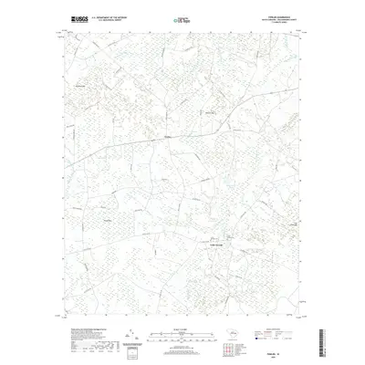
2020 Map of Fowler
USGS Topo · Published 2020About this map
Fowler sits at the heart of this Williamsburg County landscape, a rural crossroads defined by an intricate network of wetlands and family-named landmarks. The terrain is characterized by a series of "bays" and "swamps" typical of the South Carolina Coastal Plain, including the extensive Whiteoak Swamp and the unique landform of Pine Island Bay. Local history and genealogy are anchored at the Cedar Swamp Cem located near the Cedar Swamp water body. The map reveals a community connected by a dense grid of rural routes such as White Oak Rd and McFadden Rd, serving the various agricultural and timber tracts that dominate the area. Notable water features like Jack McGill Pond and the interestingly named The Morass highlight the watery nature of the local geography in this part of the Lowcountry.
Find a feature on this map
56 named features on this map. Tap any name to fly to it.
Don’t see what you’re looking for? This feature index may not catch every label — zoom into the map to look around manually.
Map Details
Editions of this 2020 Fowler Map
This is the sole edition of this map. No revisions or reprints were ever made.
Other maps of this area

1946 · Hyman
USGS Topo · 1:62,500

1946 · Kingstree
USGS Topo · 1:62,500

1946 · Lake City
USGS Topo · 1:62,500

1946 · Indiantown
USGS Topo · 1:62,500

1949 · Georgetown
USGS Topo · 1:250,000

1967 · Georgetown
USGS Topo · 1:250,000

1974 · Georgetown
USGS Topo · 1:250,000

1986 · Kingstree
USGS Topo · 1:100,000
1990 · Lake City East
USGS Topo · 1:24,000
1990 · Indiantown
USGS Topo · 1:24,000