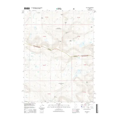
2014 Map of Fox Lake
USGS Topo · Published 2014About this map
Fox Lake sits at the heart of this high-elevation alpine landscape, where the boundary between Summit and Duchesne counties traverses the peaks of the Uinta Mountains. This 2014 survey documents a network of glacial lakes and headwater streams, including the Uinta River and Shale Creek, which drain the southern slopes of the range. The terrain is defined by dramatic elevation changes, marked by prominent landmarks such as Thompson Peak and North Burro Peak.
Find a feature on this map
50 named features on this map. Tap any name to fly to it.
Don’t see what you’re looking for? This feature index may not catch every label — zoom into the map to look around manually.
Map Details
Editions of this 2014 Fox Lake Map
This is the sole edition of this map. No revisions or reprints were ever made.
Other maps of this area

1885 · Uinta
USGS Topo · 1:250,000

1905 · Gilbert Peak
USGS Topo · 1:125,000

1906 · Gilbert Peak
USGS Topo · 1:125,000

1954 · Salt Lake City
USGS Topo · 1:250,000

1958 · Salt Lake City
USGS Topo · 1:250,000

1960 · Salt Lake City
USGS Topo · 1:250,000
1965 · Rasmussen Lakes
USGS Topo · 1:24,000

1965 · Mount Emmons
USGS Topo · 1:24,000
1965 · Kings Peak
USGS Topo · 1:24,000
1965 · Chepeta Lake
USGS Topo · 1:24,000