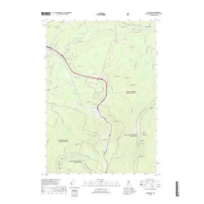
2018 Map of Franconia
USGS Topo · Published 2018About this map
Franconia Notch serves as the dramatic centerpiece of this survey, where the Pemigewasset River flows between the towering massifs of the White Mountains. To the east, the high ridgeline is defined by Mt Lafayette and Mt Lincoln, while Cannon Mtn dominates the western skyline above the waters of Profile Lake. The northern portion of the map transitions from these high peaks to the valley floor, where the village of Franconia sits along the Gale River. Evidence of the region's long-standing recreational and conservation history is visible through the extensive network of trails and the borders of the White Mountain National Forest. Detailed features such as Elmwood Cem and the Franconia Airport provide local context for the settlement, while landmarks like Artists Bluff and Bridal Veil Falls highlight the unique topography that has drawn visitors to this part of Grafton County for generations.
Find a feature on this map
97 named features on this map. Tap any name to fly to it.
Don’t see what you’re looking for? This feature index may not catch every label — zoom into the map to look around manually.
Map Details
Editions of this 2018 Franconia Map
This is the sole edition of this map. No revisions or reprints were ever made.
Other maps of this area

1900 · Whitefield
USGS Topo · 1:62,500

1929 · Moosilauke
USGS Topo · 1:62,500

1929 · Franconia
USGS Topo · 1:62,500

1931 · Littleton
USGS Topo · 1:62,500

1932 · Franconia
USGS Topo · 1:62,500

1932 · Littleton
USGS Topo · 1:48,000

1932 · Moosilauke
USGS Topo · 1:62,500

1935 · Littleton
USGS Topo · 1:62,500

1935 · Whitefield
USGS Topo · 1:48,000

1938 · Whitefield
USGS Topo · 1:62,500