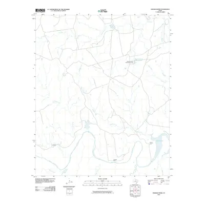
2010 Map of Franklin Bend
USGS Topo · Published 2010About this map
The Wichita River snakes through the ranching country of Wilbarger County, forming the prominent loop of Franklin Bend in the southern portion of this landscape. In the early 21st century, the terrain remains defined by extensive cattle operations, marked by remote outposts like La Paloma Cow Camp and Sweet La Cruz Cow Camp. These camps, along with the Waggoner Ranch Lake Number 1, indicate the enduring legacy of the historic Waggoner Ranch, one of the largest private estates in Texas.
Find a feature on this map
16 named features on this map. Tap any name to fly to it.
Don’t see what you’re looking for? This feature index may not catch every label — zoom into the map to look around manually.
Map Details
Editions of this 2010 Franklin Bend Map
This is the sole edition of this map. No revisions or reprints were ever made.
Other maps of this area

1917 · Beaver Creek
USGS Topo · 1:24,000

1920 · Beaver Creek
USGS Topo · 1:31,680

1932 · Dundee
USGS Topo · 1:62,500

1954 · Wichita Falls
USGS Topo · 1:250,000

1958 · Wichita Falls
USGS Topo · 1:250,000

1963 · Dundee
USGS Topo · 1:24,000

1966 · Franklin Bend
USGS Topo · 1:24,000

1966 · Fulda
USGS Topo · 1:24,000

1966 · Grayback
USGS Topo · 1:24,000
1966 · Lake Diversion
USGS Topo · 1:24,000