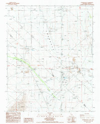
1987 Map of Franklin Well
USGS Topo · Published 1987About this map
The Amargosa Valley straddles the California and Nevada border in this late-1980s topographical record, revealing a landscape defined by water management and mineral extraction. The ephemeral Amargosa River is flanked by an extensive Levee system, while numerous tailings ponds and Claypits indicate the area's industrial activity. Cultural markers like the Clay Camp site and a Trailer Park suggest the ephemeral nature of local settlement tied to these desert industries. Historic transit corridors are prominent, including the Von Schmidt Line and a long Old Railroad Grade that cuts across the valley floor toward the southern reaches near Bat Mountain. This survey effectively captures the intersection of natural features like Ash Tree Spring with heavy human modifications, including a Landing Strip and multiple borrow pits, all set against the eastern boundary of the Ash Meadows National Wildlife Refuge.
Find a feature on this map
31 named features on this map. Tap any name to fly to it.
Don’t see what you’re looking for? This feature index may not catch every label — zoom into the map to look around manually.
Map Details
Editions of this 1987 Franklin Well Map
This is the sole edition of this map. No revisions or reprints were ever made.
Other maps of this area

1908 · Furnace Creek
USGS Topo · 1:250,000

1910 · Furnace Creek
USGS Topo · 1:250,000

1942 · Skull Mountain
USGS Topo · 1:125,000

1942 · Bullfrog
USGS Topo · 1:125,000

1948 · Death Valley
USGS Topo · 1:250,000

1952 · Ash Meadows
USGS Topo · 1:62,500

1952 · Ryan
USGS Topo · 1:62,500

1952 · Big Dune
USGS Topo · 1:62,500

1954 · Death Valley
USGS Topo · 1:250,000

1956 · Death Valley
USGS Topo · 1:250,000