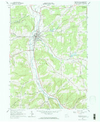
1963 Map of Franklinville
USGS Topo · Published 1964About this map
Ischua Creek carves a deep valley through the Cattaraugus hills, serving as the primary corridor for both the Pennsylvania railroad and the village of Franklinville. This 1963 field-checked survey illustrates a rural landscape defined by narrow valley settlements and high upland ridges like Kingsbury Hill and East Hill. In the village center, the High Sch and Waterworks reflect the established local infrastructure, while the presence of Coal Chutes along the rail line north of Cadiz points to the area's mid-century industrial dependencies. The map provides significant genealogical value, documenting several historic burying grounds including Ten Broeck Cem and Mt Prospect Cem. Outside the main valley, smaller communities like Fitch and Ischua are connected by a network of hollow roads, such as North Hollow Road and Williams Hollow Road, which navigate the steep terrain surrounding the State Reforestation Area.
Find a feature on this map
53 named features on this map. Tap any name to fly to it.
Don’t see what you’re looking for? This feature index may not catch every label — zoom into the map to look around manually.
Map Details
Editions of this 1963 Franklinville Map
2 editions found
Other maps of this area

1898 · Olean
USGS Topo · 1:62,500

1900 · Salamanca
USGS Topo · 1:62,500

1924 · Ellicottville
USGS Topo · 1:62,500

1924 · Franklinville
USGS Topo · 1:62,500

1938 · Salamanca
USGS Topo · 1:62,500

1938 · Olean
USGS Topo · 1:62,500

1941 · Ellicottville
USGS Topo · 1:62,500

1942 · Franklinville
USGS Topo · 1:62,500

1943 · Olean
USGS Topo · 1:62,500

1943 · Salamanca
USGS Topo · 1:62,500