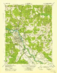
1944 Map of Fredericksburg
USGS Topo · Published 1944About this map
Fredericksburg and the surrounding riverfront of the Rappahannock River appear here in a wartime 1944 edition, showing the city's complex integration of Civil War memory and mid-century development. The map meticulously documents the grounds of the Fredericksburg Battle Field 1862, alongside both the Confederate Cem and the National Memorial Cem. The transportation corridor is anchored by the Richmond Fredericksburg and Potomac Railroad and the Jefferson Davis Highway, which pass through a landscape dotted with outlying settlements like Falmouth and Sylvania Heights. Education and civic life are prominent, with the campus of Mary Washington College situated on the western ridge and various rural schoolhouses such as Elijah Sch and Little Falls Sch serving the Stafford County side of the river. The presence of the Meade Pyramid and Howison PO provides specific points of interest for those tracing the historical geography of the Rappahannock valley.
Find a feature on this map
50 named features on this map. Tap any name to fly to it.
Don’t see what you’re looking for? This feature index may not catch every label — zoom into the map to look around manually.
Map Details
Editions of this 1944 Fredericksburg Map
This is the sole edition of this map. No revisions or reprints were ever made.
Other maps of this area

1887 · Spottsylvania
USGS Topo · 1:125,000

1889 · Fredericksburg
USGS Topo · 1:125,000

1892 · Fredericksburg
USGS Topo · 1:125,000

1892 · Spottsylvania
USGS Topo · 1:125,000

1894 · Fredericksburg
USGS Topo · 1:125,000

1926 · Stafford
USGS Topo · 1:62,500

1931 · Stafford
USGS Topo · 1:62,500

1942 · Guinea
USGS Topo · 1:31,680

1942 · Spotsylania
USGS Topo · 1:31,680

1942 · Rappahannock Academy
USGS Topo · 1:31,680