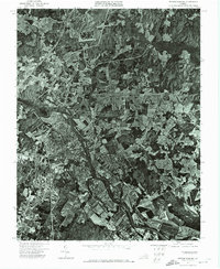
1972 Map of Fredericksburg
USGS Topo · Published 1974About this map
Fredericksburg and its surrounding landscape appear in sharp photographic detail in this 1972 orthophotomap, which utilizes high-altitude aerial imagery to reveal the development of the region at the start of the decade. The Rappahannock River serves as the central geographic feature, winding through the core of the area and separating the city from the historic settlement of Falmouth to the north. Unlike traditional topographic maps that use symbols and contours, this orthophoto provides a direct visual record of land use, showing the residential expansion in Sylvania Heights and the dense clustering of the downtown riverfront. This perspective allows researchers to see the exact footprint of industrial sites, roadways, and wooded buffers as they existed during a period of significant growth in Stafford County.
Find a feature on this map
4 named features on this map. Tap any name to fly to it.
Don’t see what you’re looking for? This feature index may not catch every label — zoom into the map to look around manually.
Map Details
Editions of this 1972 Fredericksburg Map
This is the sole edition of this map. No revisions or reprints were ever made.
Other maps of this area

1887 · Spottsylvania
USGS Topo · 1:125,000

1889 · Fredericksburg
USGS Topo · 1:125,000

1892 · Fredericksburg
USGS Topo · 1:125,000

1892 · Spottsylvania
USGS Topo · 1:125,000

1894 · Fredericksburg
USGS Topo · 1:125,000

1926 · Stafford
USGS Topo · 1:62,500

1931 · Stafford
USGS Topo · 1:62,500

1942 · Guinea
USGS Topo · 1:31,680

1942 · Spotsylania
USGS Topo · 1:31,680

1942 · Rappahannock Academy
USGS Topo · 1:31,680