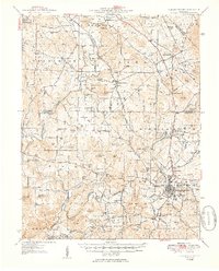
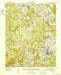
1950 Map of Fredericktown
USGS Topo · Published 1950About this map
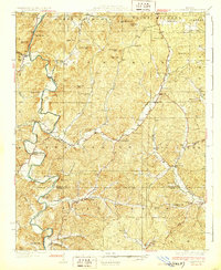
The St. Francis River and its numerous tributaries, including Musco Creek and Piney Creek, anchor this landscape in the eastern Ozarks during the mid-20th century. Industrial lead mining operations heavily influence the local geography, notably at Mine La Motte, where the Mine La Motte Lake and St Joseph Lead Mines appear alongside the residential hubs of Slabtown and Stringtown. The southern portion is dominated by the city of Fredericktown, which serves as a major node for the Missouri Pacific railroad.
Find a feature on this map
105 named features on this map. Tap any name to fly to it.
Don’t see what you’re looking for? This feature index may not catch every label — zoom into the map to look around manually.
Map Details
Editions of this 1950 Fredericktown Map
2 editions found
Other maps of this area

1904 · Farmington
USGS Topo · 1:62,500

1905 · Bonneterre
USGS Topo · 1:62,500

1906 · Farmington
USGS Topo · 1:62,500

1907 · Weingarten
USGS Topo · 1:62,500

1909 · Weingarten
USGS Topo · 1:62,500

1910 · Higdon
USGS Topo · 1:62,500
1926 · Des Arc
USGS Topo · 1:62,500
1929 · Des Arc
USGS Topo · 1:62,500
1930 · Coldwater
USGS Topo · 1:62,500

1933 · Marquand
USGS Topo · 1:62,500