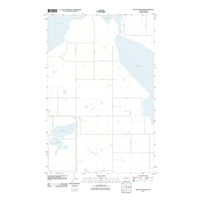
2011 Map of Free Peoples Lake
USGS Topo · Published 2011About this map
Devils Lake and East Devils Lake dominate the northern landscape of this North Dakota prairie region, where shifting shorelines have historically defined the geography of the Wood Lake District. The interior of the quadrangle is characterized by a sparse network of section roads, such as 87th St NE and 35th St NE, cutting across a terrain dotted with small glacial potholes and wetlands. To the southwest, Free Peoples Lake and Elbow Lake provide distinct landmarks in a township layout largely devoted to agriculture. Local transit is anchored by thoroughfares like Reeves Rd, which connects the scattered farmsteads and rural properties that constitute the primary human footprint in this area at the start of the twenty-first century. The map reflects a classic Great Plains land-use pattern, with infrastructure almost entirely conforming to the rectangular survey system.
Find a feature on this map
21 named features on this map. Tap any name to fly to it.
Don’t see what you’re looking for? This feature index may not catch every label — zoom into the map to look around manually.
Map Details
Editions of this 2011 Free Peoples Lake Map
This is the sole edition of this map. No revisions or reprints were ever made.
Other maps of this area

1928 · Tokio
USGS Topo · 1:62,500

1930 · Hamar
USGS Topo · 1:62,500

1931 · Tokio
USGS Topo · 1:62,500

1931 · Devils Lake
USGS Topo · 1:62,500

1950 · Tokio
USGS Topo · 1:24,000

1950 · Devils Lake
USGS Topo · 1:62,500

1950 · Devils Lake Mountain
USGS Topo · 1:24,000

1951 · Crary
USGS Topo · 1:24,000

1951 · Devils Lake Mountain
USGS Topo · 1:24,000

1951 · Devils Lake
USGS Topo · 1:24,000