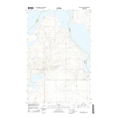
2014 Map of Free Peoples Lake
USGS Topo · Published 2014About this map
Free Peoples Lake and the shifting shorelines of the Devils Lake basin define this northern plains landscape. Situated on the boundary of Ramsey County and Benson County, the area is characterized by a dense network of glacial prairie potholes and larger bodies of water like East Devils Lake and Elbow Lake. The map reveals the intricate local grid of section roads, including Nd-20, which connects the scattered wetlands and farmsteads. The fluctuating water levels of this region are evident in the complex topography around the lakes, where local thoroughfares like 88th Ave NE and 34th St NE navigate the low-lying terrain. This survey provides a precise view of the rural infrastructure and hydrography in the Wood Lake District before recent decades of rising lake levels significantly altered the geography of the basin.
Find a feature on this map
23 named features on this map. Tap any name to fly to it.
Don’t see what you’re looking for? This feature index may not catch every label — zoom into the map to look around manually.
Map Details
Editions of this 2014 Free Peoples Lake Map
This is the sole edition of this map. No revisions or reprints were ever made.
Other maps of this area

1928 · Tokio
USGS Topo · 1:62,500

1930 · Hamar
USGS Topo · 1:62,500

1931 · Tokio
USGS Topo · 1:62,500

1931 · Devils Lake
USGS Topo · 1:62,500

1950 · Tokio
USGS Topo · 1:24,000

1950 · Devils Lake
USGS Topo · 1:62,500

1950 · Devils Lake Mountain
USGS Topo · 1:24,000

1951 · Crary
USGS Topo · 1:24,000

1951 · Devils Lake Mountain
USGS Topo · 1:24,000

1951 · Devils Lake
USGS Topo · 1:24,000