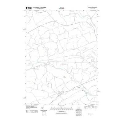
2010 Map of Freeburg
USGS Topo · Published 2010About this map
Freeburg sits at the heart of this landscape, where the rural valleys of Snyder County meet the southern slopes of Middle Creek Mountain. The area is characterized by a series of southwest-to-northeast running valleys, including Pleasant Valley, Flint Valley, and Neitz Valley, all drained by the winding course of Middle Creek. This terrain shaped a dense network of local routes like Apple Butter Rd and Erdly Church Rd, connecting scattered family farms and homesteads across the ridges. Local heritage is deeply etched into the land at Globe Mills Cemetery, Fairview Cemetery, and Evergreen Cemetery. Northward, the waters of Penns Creek and Monongahela Creek further define the geography, reflecting the enduring agricultural and residential character of this central Pennsylvania region.
Find a feature on this map
76 named features on this map. Tap any name to fly to it.
Don’t see what you’re looking for? This feature index may not catch every label — zoom into the map to look around manually.
Map Details
Editions of this 2010 Freeburg Map
This is the sole edition of this map. No revisions or reprints were ever made.
Other maps of this area

1893 · Sunbury
USGS Topo · 1:62,500

1893 · Millersburg
USGS Topo · 1:62,500

1907 · Millerstown
USGS Topo · 1:62,500

1938 · Mifflinburg
USGS Topo · 1:48,000

1943 · Millerstown
USGS Topo · 1:62,500

1943 · Millersburg
USGS Topo · 1:62,500

1943 · Sunbury
USGS Topo · 1:62,500

1943 · Mifflinburg
USGS Topo · 1:62,500
1947 · Pillow
USGS Topo · 1:24,000
1947 · Dalmatia
USGS Topo · 1:24,000