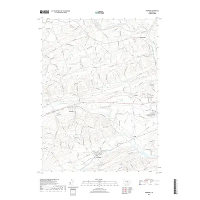
2019 Map of Freeburg
USGS Topo · Published 2019About this map
Selinsgrove and the nearby campus of Susquehanna University anchor the eastern edge of this landscape, where the terrain transitions into a series of parallel valleys defined by Mid Creek Mtn and Bake Oven Hill. The settlement pattern follows these natural corridors, with Pleasant Valley, Flint Valley, and Neitz Valley housing small rural communities. The map reveals a high density of named roads and family landmarks, such as Ben-Walt Ln and Scrubby Hill Rd, providing valuable data for local researchers.
Find a feature on this map
165 named features on this map. Tap any name to fly to it.
Don’t see what you’re looking for? This feature index may not catch every label — zoom into the map to look around manually.
Map Details
Editions of this 2019 Freeburg Map
This is the sole edition of this map. No revisions or reprints were ever made.
Other maps of this area

1893 · Sunbury
USGS Topo · 1:62,500

1893 · Millersburg
USGS Topo · 1:62,500

1907 · Millerstown
USGS Topo · 1:62,500

1938 · Mifflinburg
USGS Topo · 1:48,000

1943 · Millerstown
USGS Topo · 1:62,500

1943 · Millersburg
USGS Topo · 1:62,500

1943 · Sunbury
USGS Topo · 1:62,500

1943 · Mifflinburg
USGS Topo · 1:62,500
1947 · Pillow
USGS Topo · 1:24,000
1947 · Dalmatia
USGS Topo · 1:24,000