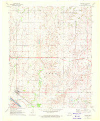
1970 Map of Freedom
USGS Topo · Published 1972About this map
The town of Freedom sits at the intersection of local history and the sprawling plains of northwestern Oklahoma, positioned just north of the Cimarron River. This 1970 survey illustrates a landscape defined by its waterways and ranching heritage, with several family and community landmarks such as Freedom Cem and Preston Hill Cem scattered across the township. The Atchison Topeka and Santa Fe railroad skirts the southwestern edge of the settlement, mirroring the river's path and providing a vital transport link for the region's agriculture and resource extraction, evidenced by various Oil Wells and Gas Wells throughout the quadrangle.
Find a feature on this map
27 named features on this map. Tap any name to fly to it.
Don’t see what you’re looking for? This feature index may not catch every label — zoom into the map to look around manually.
Map Details
Editions of this 1970 Freedom Map
This is the sole edition of this map. No revisions or reprints were ever made.
Other maps of this area

1955 · Woodward
USGS Topo · 1:250,000

1958 · Woodward
USGS Topo · 1:250,000

1969 · Waynoka NW
USGS Topo · 1:24,000

1969 · Tegarden NW
USGS Topo · 1:24,000

1969 · Tegarden
USGS Topo · 1:24,000

1970 · Alabaster Caverns
USGS Topo · 1:24,000

1970 · Freedom NE
USGS Topo · 1:24,000

1970 · Fairvalley
USGS Topo · 1:24,000

1970 · Freedom NW
USGS Topo · 1:24,000

1970 · Edith
USGS Topo · 1:24,000