
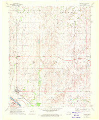
1970 Map of Freedom NW
USGS Topo · Published 1972About this map
The Kansas-Oklahoma state line forms the northern boundary of this landscape, where the Comanche and Woods County border intersects the prairie. The terrain is defined by a dense network of drainage systems, primarily feeding into the Red Fork and the winding channels of Moccasin Creek and West Moccasin Creek. In the upland areas, the township divisions of Patterson and Obryan segment the land into a grid of section lines and unimproved roads.
Find a feature on this map
16 named features on this map. Tap any name to fly to it.
Don’t see what you’re looking for? This feature index may not catch every label — zoom into the map to look around manually.
Map Details
Editions of this 1970 Freedom NW Map
This is the sole edition of this map. No revisions or reprints were ever made.
Other maps of this area

1892 · Coldwater
USGS Topo · 1:125,000

1955 · Woodward
USGS Topo · 1:250,000

1955 · Pratt
USGS Topo · 1:250,000

1958 · Woodward
USGS Topo · 1:250,000

1959 · Pratt
USGS Topo · 1:250,000

1970 · Lookout
USGS Topo · 1:24,000

1970 · Freedom NE
USGS Topo · 1:24,000

1970 · Edith
USGS Topo · 1:24,000
1970 · Freedom
USGS Topo · 1:24,000

1971 · Selman SE
USGS Topo · 1:24,000