
1943 Map of Freeland
USGS Topo · Published 1962About this map
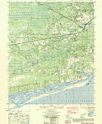
The Waccamaw River carves a winding path through the heart of this landscape, defining the border between Columbus Co and Brunswick Co. During the early 1940s, the region was characterized by extensive wetlands and swampy basins like Bee Tree Swamp and King Swamp, interspersed with small settlements such as Freeland and Ash. The topography reveals an area reliant on timber and agriculture, with evidence of earlier industry visible in the Old Railroad Grade that cuts through Simmons Bay Lees. Community life is anchored by local landmarks including New Britton Ch, Gore Chapel, and the Waccamaw Sch. The presence of several bridges, such as Bear Branch Bridge and Wet Ash Bridge, highlights the critical infrastructure required to navigate the dense network of tributaries like Bear Branch and Possum Br that feed into the Waccamaw.
Find a feature on this map
50 named features on this map. Tap any name to fly to it.
Don’t see what you’re looking for? This feature index may not catch every label — zoom into the map to look around manually.
Map Details
Editions of this 1943 Freeland Map
This is the sole edition of this map. No revisions or reprints were ever made.
Other maps of this area

1942 · Juniper Creek
USGS Topo · 1:24,000

1943 · Pireway
USGS Topo · 1:31,680

1943 · Nakina
USGS Topo · 1:24,000

1943 · Calabash
USGS Topo · 1:31,680

1943 · Exum
USGS Topo · 1:24,000

1943 · Shallotte
USGS Topo · 1:24,000

1944 · Longs
USGS Topo · 1:31,680

1944 · Shallotte
USGS Topo · 1:31,680

1949 · Georgetown
USGS Topo · 1:250,000
1950 · Shallotte
USGS Topo · 1:25,000