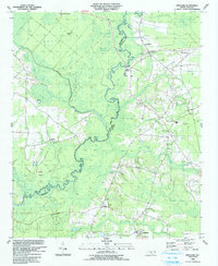
1990 Map of Freeland
USGS Topo · Published 1991About this map
The Waccamaw River carves a winding path along the border of Columbus and Brunswick counties, anchoring a landscape defined by extensive wetlands and scattered rural settlements in the late 1980s. The river's serpentine course is flanked by large named tracts of low-lying terrain like Bee Tree Swamp and Hog Swamp, punctuated by higher ground such as Sand Hill and Sweetgum Island.
Find a feature on this map
52 named features on this map. Tap any name to fly to it.
Don’t see what you’re looking for? This feature index may not catch every label — zoom into the map to look around manually.
Map Details
Editions of this 1990 Freeland Map
This is the sole edition of this map. No revisions or reprints were ever made.
Other maps of this area

1942 · Juniper Creek
USGS Topo · 1:24,000

1943 · Pireway
USGS Topo · 1:31,680

1943 · Nakina
USGS Topo · 1:24,000

1943 · Calabash
USGS Topo · 1:31,680

1943 · Freeland
USGS Topo · 1:24,000

1943 · Exum
USGS Topo · 1:24,000

1943 · Shallotte
USGS Topo · 1:24,000

1944 · Longs
USGS Topo · 1:31,680

1944 · Shallotte
USGS Topo · 1:31,680

1949 · Georgetown
USGS Topo · 1:250,000