Loading...
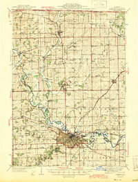
Loading map...1944 Map of Freeport
USGS Topo · Published 1944About this map
The city of Freeport serves as a dense industrial and rail hub in this mid-century Illinois landscape, where the Pecatonica River and Yellow Creek converge. The urban center is framed by extensive railroad infrastructure, including the Illinois Central, Chicago Milwaukee St Paul and Pacific, and the Chicago and North Western lines. Notable logistical features like the Wallace Yards at West Junction highlight the importance of the rail economy during this era.
Find a feature on this map
103 named features on this map. Tap any name to fly to it.
Don’t see what you’re looking for? This feature index may not catch every label — zoom into the map to look around manually.
Map Details
Date Portrayed1944
Date Published1944
PublisherU.S. Geological Survey
Map TypeTopographic
Scale1:62,500
Physical Dimensions15.9 x 20.8 inches
Editions of this 1944 Freeport Map
This is the sole edition of this map. No revisions or reprints were ever made.
Historical Maps of Freeport Through Time
Featured Locations
Source Details
SourceU.S. Geological Survey
CopyrightPublic Domain