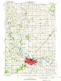
1939 Map of Freeport
USGS Topo · Published 1966About this map
The Pecatonica River winds through the heart of Stephenson County, anchoring a landscape defined by the intersection of three major railroads. Industrial activity and transit are centered around Freeport, where the Illinois Central, Chicago and North Western, and Chicago Milwaukee St Paul and Pacific converge. The massive Wallace Yards on the city's eastern edge highlight the importance of rail logistics during this era.
Find a feature on this map
95 named features on this map. Tap any name to fly to it.
Don’t see what you’re looking for? This feature index may not catch every label — zoom into the map to look around manually.
Map Details
Editions of this 1939 Freeport Map
2 editions found
Other maps of this area

1893 · Brodhead
USGS Topo · 1:62,500

1920 · Monroe
USGS Topo · 1:62,500

1922 · Monroe
USGS Topo · 1:62,500

1922 · Oregon
USGS Topo · 1:62,500

1923 · South Wayne
USGS Topo · 1:62,500

1924 · Oregon
USGS Topo · 1:62,500

1932 · Pecatonica
USGS Topo · 1:62,500

1936 · Pecatonica
USGS Topo · 1:62,500

1937 · Lena
USGS Topo · 1:48,000

1939 · Freeport
USGS Topo · 1:48,000