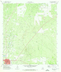
1971 Map of Freer North
USGS Topo · Published 1974About this map
Government Wells Field and the Seven Sisters Oil Field define this South Texas landscape, where a dense network of pipelines and pumping stations reflects the region's intensive petroleum production in the early 1970s. The town of Freer serves as the primary hub in the southwest corner, showing a detailed layout including the High Sch, Hospital, and a local Drive-in Theater near the Landing Strip. Cultural landmarks like the Hahl Memorial Cem provide touchpoints for local genealogists, while the terrain is marked by the drainages of Government Wells Creek and Tarancahuas Creek. This survey captures the height of the mid-century oil boom's infrastructure, from the Loma Novia Field to the scattered settlements like Walker, illustrating how energy extraction shaped the settlement patterns and road networks of Duval County.
Find a feature on this map
22 named features on this map. Tap any name to fly to it.
Don’t see what you’re looking for? This feature index may not catch every label — zoom into the map to look around manually.
Map Details
Editions of this 1971 Freer North Map
This is the sole edition of this map. No revisions or reprints were ever made.
Other maps of this area

1920 · Mikeska
USGS Topo · 1:125,000

1937 · Loma Alta
USGS Topo · 1:62,500

1953 · Crystal City
USGS Topo · 1:250,000

1955 · Crystal City
USGS Topo · 1:250,000

1956 · Rosita Ranch
USGS Topo · 1:62,500

1956 · Freer
USGS Topo · 1:62,500

1956 · Laredo
USGS Topo · 1:250,000

1961 · Crystal City
USGS Topo · 1:250,000

1968 · Crystal City
USGS Topo · 1:250,000
1968 · Rosita
USGS Topo · 1:24,000