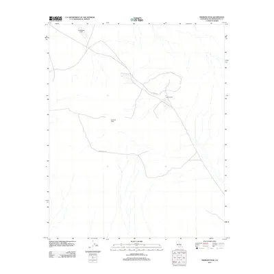
2012 Map of Fremont Peak
USGS Topo · Published 2012About this map
Hamburger Mill stands as a primary point of interest in this high-desert portion of San Bernardino County. The landscape is dominated by the prominent rise of Fremont Peak, which anchors the central terrain and provides the namesake for this 2012 survey. To the northwest, the dry bed of Cuddeback Lake reaches into the quadrangle, reflecting the arid character of the Mojave Desert. Remote desert tracks such as Hoffman Rd and Fremont Peak Rd provide the only significant access through these sprawling basins. The absence of traditional townsites underscores the industrial and topographical focus of this era, where localized features like the mill and major geological landmarks define the human and physical geography of the region.
Find a feature on this map
5 named features on this map. Tap any name to fly to it.
Don’t see what you’re looking for? This feature index may not catch every label — zoom into the map to look around manually.
Map Details
Editions of this 2012 Fremont Peak Map
This is the sole edition of this map. No revisions or reprints were ever made.
Other maps of this area

1903 · Randsburg
USGS Topo · 1:62,500

1911 · Randsburg
USGS Topo · 1:62,500

1912 · Randsburg
USGS Topo · 1:62,500

1915 · Searles Lake
USGS Topo · 1:250,000

1947 · Johannesburg SE
USGS Topo · 1:25,000

1947 · Trona
USGS Topo · 1:250,000

1948 · Trona
USGS Topo · 1:250,000

1953 · Trona
USGS Topo · 1:250,000
1954 · Boron
USGS Topo · 1:62,500

1954 · Cuddeback Lake
USGS Topo · 1:62,500