1903 Map of Randsburg
USGS Topo · Published 1903About this map
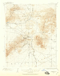
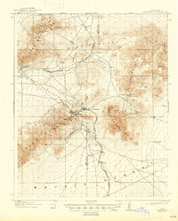
Randsburg and Johannesburg serve as the industrial hubs of this high desert landscape during the peak of California's desert gold boom. This survey, conducted by L.C. Fletcher and J. E. Rockhold, captures the critical infrastructure of the mining district, where the Yellow Aster Mine dominates the slopes of Government Peak. The survival of these settlements relied on a network of water sources such as Squaw Spring, Willow Spring, and Mountain Wells, scattered across the arid terrain of the Mojave Desert.
Find a feature on this map
27 named features on this map. Tap any name to fly to it.
Don’t see what you’re looking for? This feature index may not catch every label — zoom into the map to look around manually.
Map Details
Editions of this 1903 Randsburg Map
This is the sole edition of this map. No revisions or reprints were ever made.