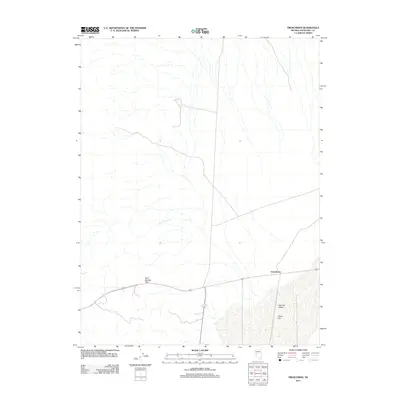
2011 Map of Frenchman
USGS Topo · Published 2011About this map
Frenchman occupies a central point in this Churchill County landscape, situated along the corridor of U.S. Route 50. The terrain is characterized by the broad, open expanse of Fairview Valley and the distinct dry basin of Labou Flat to the south. Transportation routes are the primary human imprint on this part of the Great Basin, with the road network navigating through the Sand Springs Pass. This modern digital survey from the U.S. Geological Survey documents the relationship between these desert landforms and the infrastructure connecting small Nevada settlements, illustrating how local roads like Route 31 839 interface with the primary highway.
Find a feature on this map
6 named features on this map. Tap any name to fly to it.
Don’t see what you’re looking for? This feature index may not catch every label — zoom into the map to look around manually.
Map Details
Editions of this 2011 Frenchman Map
This is the sole edition of this map. No revisions or reprints were ever made.
Other maps of this area

1908 · Carson Sink
USGS Topo · 1:250,000

1910 · Carson Sink
USGS Topo · 1:250,000

1957 · Reno
USGS Topo · 1:250,000

1959 · Reno
USGS Topo · 1:250,000

1960 · Reno
USGS Topo · 1:250,000

1972 · Pirouette Mtn
USGS Topo · 1:24,000

1972 · Fourmile Flat
USGS Topo · 1:24,000

1972 · Diamond Canyon
USGS Topo · 1:24,000
1972 · Bell Canyon
USGS Topo · 1:24,000
1972 · Drumm Summit
USGS Topo · 1:24,000