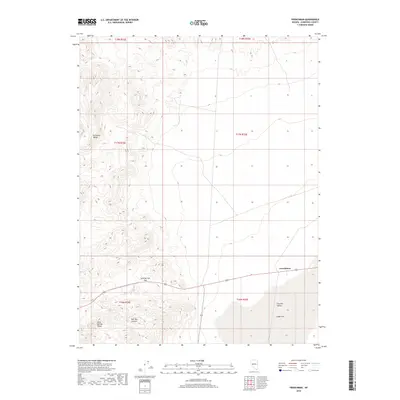
2018 Map of Frenchman
USGS Topo · Published 2018About this map
Frenchman occupies a central point in this Churchill County landscape, situated where the road descends into the expansive Fairview Valley. This 2018 survey reveals a terrain of dramatic contrasts, where the high ridges of the Stillwater Range and the Sand Springs Range dominate the western half of the quadrangle. These mountainous features are bisected by Sand Springs Pass, providing a natural corridor through the desert heights.
Find a feature on this map
13 named features on this map. Tap any name to fly to it.
Don’t see what you’re looking for? This feature index may not catch every label — zoom into the map to look around manually.
Map Details
Editions of this 2018 Frenchman Map
This is the sole edition of this map. No revisions or reprints were ever made.
Other maps of this area

1908 · Carson Sink
USGS Topo · 1:250,000

1910 · Carson Sink
USGS Topo · 1:250,000

1957 · Reno
USGS Topo · 1:250,000

1959 · Reno
USGS Topo · 1:250,000

1960 · Reno
USGS Topo · 1:250,000

1972 · Pirouette Mtn
USGS Topo · 1:24,000

1972 · Fourmile Flat
USGS Topo · 1:24,000

1972 · Diamond Canyon
USGS Topo · 1:24,000
1972 · Bell Canyon
USGS Topo · 1:24,000
1972 · Drumm Summit
USGS Topo · 1:24,000